Aerial vs Ground Photos: When You Need a Drone Shot | Bash & Co
Every listing needs ground photos. Not every listing needs the property shown from above. The skill is knowing which is which before you book the shoot.
Ground photography and aerial photography answer different questions. Ground photos show the rooms, the condition, the light and the flow — how the home feels to live in. Aerial photos show the setting: the section, the boundaries, the outlook, and how the property sits in its street and suburb. Some listings sell on the inside. Others sell on where they are. The drone earns its place when the location and the land are part of the story.
Here is how to decide.
What the aerial view shows that the ground can't
A drone shot exists to answer the questions a buyer can't resolve from the footpath.
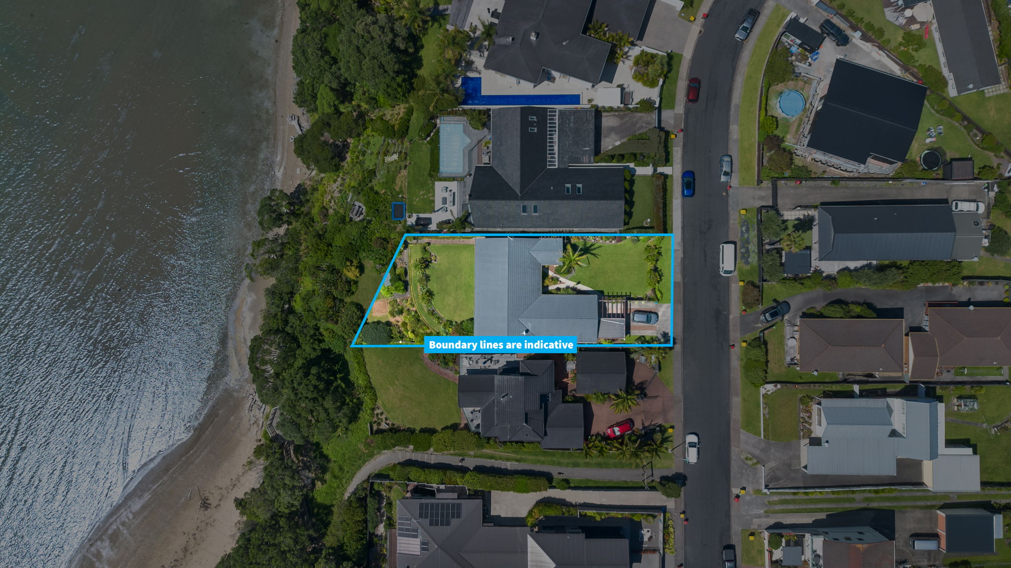
From above, a buyer can see the size of the section, where the boundaries sit, how the house is positioned on the land, and what surrounds it — reserves, water, parks, schools, the shape of the street. For a lot of Auckland properties, that context is exactly what justifies the price. If a buyer has to imagine it, you are leaving value on the table.
Ground photos, by contrast, do the emotional work. They are what make someone want the home. The two formats work together: the ground photos sell the lifestyle inside, and the aerial sells the position outside.
So the real question for each listing is simple. Is there something about this property's land, outlook or location that a ground photo cannot explain?
When a listing clearly benefits from aerial
Some properties are genuinely incomplete without an aerial perspective. If a listing fits any of these, the drone shot usually pays for itself:
Large sections — anything around 600m² and up, where the scale of the land is a selling point.
Waterfront and coastal homes — the outlook and proximity to the water are most of the value, and you can only show that from above.
Lifestyle blocks and semi-rural properties — buyers need to understand the size, layout and boundaries of the land.
Homes near parks, reserves, beaches or schools — aerial shows the amenity right there, which ground photos can only hint at.
Properties with views worth showing — an elevated frame captures a view shaft far better than a window shot.
Sections where boundaries are hard to read from the ground — corner sites, irregular shapes, long driveways.
New builds on bare or developing sections — aerial shows the plot, the position and the surrounding development.
Premium listings — where the campaign needs a stronger visual story and a more complete picture.
The common thread is that the property's value is tied to its land, position or surroundings. When that is true, aerial is not a luxury add-on. It is part of explaining the price.
When ground photos are probably enough
There are listings where a heavy aerial treatment adds little.
A small apartment in a tower, a townhouse in a dense complex, or a unit with no meaningful outdoor space or outlook may not gain much from a full drone sequence. The selling story is the interior, the fit-out and the location convenience, not the section. In those cases the budget is usually better spent on strong ground photography, a clear floor plan, virtual staging, or a short walkthrough video.
Even then, one or two elevated shots can sometimes help by showing proximity to a train station, a town centre or the waterfront. The point is proportion. A single establishing shot is different from a full aerial set, and the property should decide which one it needs.
The test is honest: would the aerial image help a buyer understand something that matters, or is it there only because drone footage looks premium? If it is the second, it is probably overkill.
A quick way to decide per listing
When you are standing at the appraisal or writing up the campaign, run through three questions:
Is the land or section a selling point? Size, shape, boundaries, usable outdoor space.
Is the location or outlook a selling point? Water, views, reserves, proximity to amenities.
Can a buyer understand those things from ground photos alone? If not, aerial fills the gap.
If you answer yes to one or two and no to the third, book the aerial. If the property's whole story lives indoors, you can lean on ground photography and put the spend elsewhere.
For most standard residential listings in Auckland, a small amount of aerial alongside strong ground photography gives buyers the full picture. That is why Bash & Co includes aerial photography in every listing package rather than treating it as an optional extra — the majority of properties benefit from at least some elevated context. For the rare listing that genuinely doesn't need it, aerial can be left out.
The Bash & Co approach
At Bash & Co, aerial is part of the listing story, not a novelty. Aerial stills are included in every listing package, and aerial video is included in the Premium and Luxury packages, because most Auckland properties have some element of land, outlook or location that buyers deserve to see clearly.
When a property has a strong aerial story — a coastal outlook, a big section, a reserve next door — we lean into it with a full set of elevated and overhead shots, and video where it adds scale. When a property's story is mostly indoors, the aerial stays light and the ground photography does the heavy lifting. Either way, the goal is the same: show the buyer everything that matters about the property, inside and out.
If you want the detail on cost, rules and timing, read our guide to real estate drone photography in Auckland, see what's covered in the aerial media service, or compare full listing options on packages and pricing.
FAQs about aerial vs ground photos
Does every listing need drone photos?
No. Aerial photography is most valuable when the land, boundaries, outlook or location are part of the selling story. For a small apartment or townhouse with no meaningful outdoor context, strong ground photos and a floor plan may be enough, though a single elevated shot can still help show location.
Which property types benefit most from aerial photography?
Large sections, waterfront and coastal homes, lifestyle blocks, properties near parks, reserves or schools, homes with views, and sections where boundaries are hard to show from the ground. These are the listings where the aerial view explains the value.
Can aerial photos replace ground photos?
No. They do different jobs. Ground photos show the interior, condition and flow that make a buyer want the home. Aerial photos show the setting and the land. A complete listing usually needs both.
Is aerial worth it for a standard residential home?
Often yes, in moderation. Even an ordinary Auckland home usually has some location or section context worth showing. A small amount of aerial alongside good ground photography gives buyers a fuller picture, which is why it's included in Bash & Co listing packages by default.