Real Estate Drone Photography Auckland: Rules & Costs | Bash & Co
Drone photography is useful when the buyer needs to understand more than the rooms inside the house.
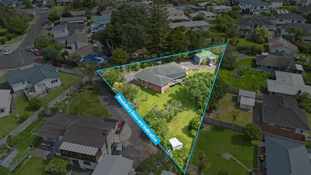
Ground photos show presentation, condition and flow. Aerial photos show context: the section, boundaries, outlook, nearby amenities, driveway access, roofline, neighbouring properties and how the home sits on the land. For many Auckland listings, that context is part of the value.
But drone photography is not just “send it up and get a few nice shots.” In Auckland, a good aerial shoot depends on the property, the weather, airspace, safety, consent and whether the drone images will actually help the campaign.
Here is when real estate drone photography is worth using, what it usually costs, and what Auckland agents should know before booking it.
What drone photography adds to a real estate listing
Drone photography gives buyers a view they cannot get from the street.
That matters because buyers are judging the position, land, aspect, neighbourhood and how easy the property is to understand before they visit.
Aerial images can show:
section size and how the house sits on the land
boundary context and outdoor areas
views, coastline, parks or reserves nearby
driveway access, parking and layout
proximity to schools, shops, beaches or transport links
roofline, pool, gardens and large outdoor features
the wider neighbourhood context around the home
For agents, the value is clarity. A buyer who understands the property before the open home is usually a better-qualified buyer when they arrive.
When a listing actually needs drone photography
Some listings benefit from aerial photography more than others.
A drone shot is especially useful when the selling point is hard to explain from ground level. That might be a large section, a coastal outlook, a reserve next door, a long driveway, a view shaft, a pool area, or a property where the home’s relationship to the land matters.
For Auckland, aerial photography often makes sense for:
waterfront, coastal or view properties
homes near parks, reserves, beaches or schools
large sections or subdividable sites
lifestyle blocks and semi-rural properties
corner sites or properties with unusual access
new builds on bare or developing sections
homes where boundaries are difficult to show from the ground
premium listings where the campaign needs a stronger visual story
If the property’s location, section or outlook helps justify the price, aerial photography usually deserves a place in the campaign.
When drone photography may be overkill
Not every listing needs a heavy aerial treatment.
A small apartment, townhouse in a dense complex, or home with no meaningful outdoor context may not need a full drone sequence. One or two elevated shots might be enough, or the campaign may be better served by stronger ground photography, a floor plan, virtual staging, or a short video.
The question is simple: will an aerial view help the buyer understand something important? If the drone image only exists because “drone looks premium,” it may not add much.
What does drone photography cost in Auckland?
Standalone aerial photography is usually priced separately when it is booked on its own. At Bash & Co, standalone aerial stills start from $175, aerial video starts from $195, and combined aerial stills plus video starts from $295.
Most agents do not need to buy aerial separately, though. Bash & Co includes aerial photography in listing packages because it works best as part of a complete campaign: ground photos, aerial photos and a floor plan at minimum.
The cost depends on a few things:
whether you need still photos, video, or both
whether aerial is part of a full listing package
the property location and access
weather or airspace constraints
the number of final images or clips needed
whether the footage is being used for social video as well as the listing
The better question: what media does this listing need to be properly understood online?
What CAA rules should Auckland agents know?
Real estate drone work in New Zealand needs to follow Civil Aviation Authority rules. The key framework for standard drone operations is Part 101.
Agents do not need to become aviation experts, but they should know enough to avoid risky operators.
Before flying, a drone operator should check:
whether the property is in controlled or restricted airspace
nearby airports, heliports or aerodromes
whether consent is needed from people or property owners affected by the flight
weather, visibility and wind conditions
safe take-off and landing areas
whether the flight can be completed without creating risk to people, property or traffic
For Bash & Co shoots, we check airspace restrictions, assess conditions and log flights through Airshare where required. If a property is near controlled airspace or an airport, extra clearance may be needed. If that clearance cannot be obtained, the responsible answer is not to fly.
Weather matters more than agents expect
Auckland weather can make or break an aerial shoot.
Strong wind, rain, low visibility and fast-changing conditions affect both safety and image quality. Even if the ground photos can go ahead, the drone portion may need to move.
That is normal. A safe operator will not force a flight just because the campaign is under time pressure.
At Bash & Co, if conditions are not safe for aerial on the day, we reschedule the aerial portion at no extra charge. It is better to get the aerial media on the right day than to deliver shaky footage, dull images or an unsafe flight.
A small practical tip: if possible, avoid booking drone-heavy shoots on rubbish and recycling collection days. Bins and trucks can clutter the very street views the aerial photos are supposed to make attractive.
Aerial stills vs aerial video
Aerial stills and aerial video do different jobs.
Aerial stills are useful for listing portals, brochures, signboards and appraisal documents. They help buyers understand the property at a glance: land, outlook, access and location.
Aerial video adds movement. It can show the approach to the home, the scale of the section, the relationship to nearby amenities, and the wider setting in a way a single frame cannot. Video is especially useful for premium campaigns, social media, coastal homes, lifestyle properties and listings where the location does a lot of the selling.
For a standard listing, aerial stills may be enough. For a higher-value campaign, aerial video can make the property feel more complete online.
What to ask before booking an aerial photographer
Before booking drone photography for a listing, ask a few simple questions:
Do you check airspace and CAA requirements before flying?
What happens if the weather is unsafe on the day?
Are aerial photos included in the listing package or priced separately?
How many final aerial images will be delivered?
Do you provide aerial video as well as stills?
How quickly will the edited files be delivered?
The answers tell you whether you are booking a proper real estate media operator or just someone with a drone.
The Bash & Co approach to aerial media
At Bash & Co, aerial photography is treated as part of the listing story, not a novelty shot.
We use it to show what buyers need to understand: boundaries, views, scale, access, outdoor areas and neighbourhood context. Aerial stills are included in every Bash & Co listing package, and aerial video is included in Premium and Luxury packages.
Typical aerial stills are delivered within 24 hours. Aerial video is usually delivered within 72 hours. We check airspace, weather and safety before flying, and if conditions are not right, we reschedule the aerial portion rather than forcing it.
If you are planning an Auckland listing and want the property shown properly from ground level and above, start with the real estate aerial media service or compare full listing options on packages and pricing.
FAQs about real estate drone photography
Is drone photography worth it for every real estate listing?
It depends on the property. Drone photography is most useful when it helps buyers understand section size, boundaries, views, access, outdoor areas or neighbourhood context. For smaller properties with no meaningful aerial story, a few elevated shots may be enough.
How much does real estate drone photography cost in Auckland?
Standalone aerial stills at Bash & Co start from $175, aerial video from $195, and combined aerial stills plus video from $295. Most listing clients do not need standalone aerial pricing because aerial photography is included in Bash & Co listing packages.
Can drones fly anywhere in Auckland?
No. Some locations are affected by controlled airspace, nearby airports, restricted areas, weather or safety constraints. A responsible operator checks airspace and conditions before flying and will not fly if clearance or safe conditions are not available.
What is better: aerial photos or aerial video?
Aerial photos are best for listing portals, brochures and quick buyer understanding. Aerial video is better when movement helps show scale, approach, views or location. Many premium campaigns use both.